Where can the building go?
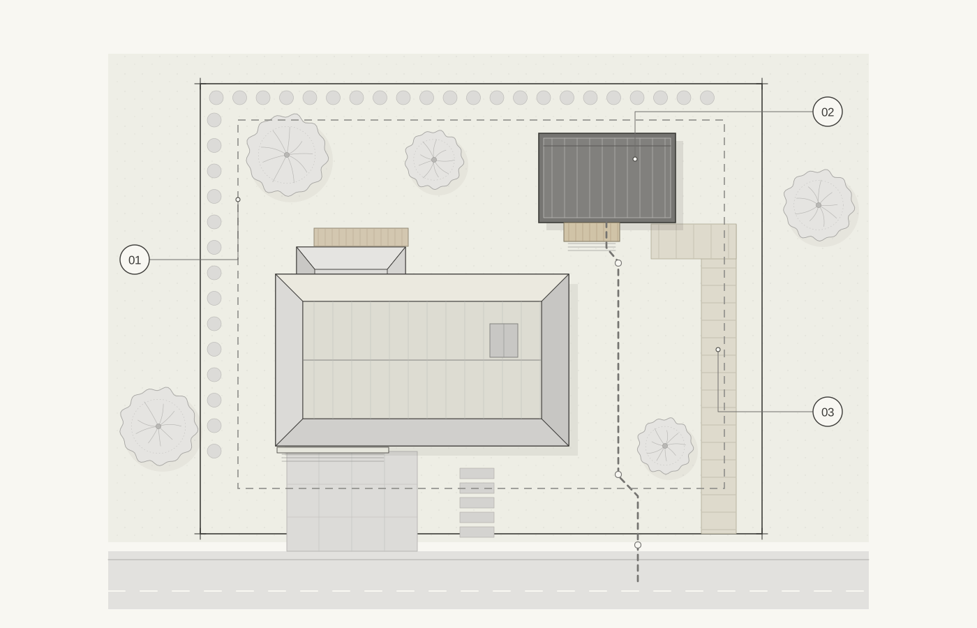 EXAMPLE LAYOUT · NOT A SURVEY
EXPLORE THE LOT
Find the space you can use
Use a legal survey to confirm boundaries. Zoning, fire separation and title restrictions shape the buildable space; fences and online maps do not replace a survey.
What to check next
- Bring or request
- Current survey + the zone’s siting rules
- Who can help
- BC land surveyor, designer and District
- When it matters
- Before settling on the building position.
DISTRICT OF SQUAMISH
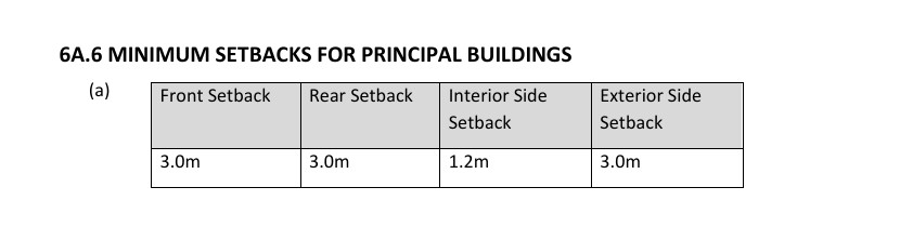
R-1 zoning excerpt
R-1 setbacks for principal buildings. For an ADU, also check the separate siting rules in the current bylaw.
Read the District documentPrincipal-building setbacks · section 6A.6
Posted R-1 extract includes 2024 amendments · Updated October 3, 2026
Check the actual boundaries, existing buildings, title restrictions and proposed use together. Use a legal survey to confirm boundaries, rather than relying on fences or online map lines.
Setbacks
Space required between a building and a property line. Check the zone, building type and corner-lot conditions.
Height
A defined bylaw measurement. Confirm how proposed ground and flood-related floor levels affect it.
Lot coverage
The portion of the lot covered by buildings under the bylaw definition. Existing structures matter.
Floor area ratio
A separate floor-area allowance. A footprint can fit while the total floor area exceeds the applicable limit.
What are the R-1 setback numbers?
- Principal building, section 6A.6: 3 m front and rear; 1.2 m interior side; 3 m exterior side.
- ADU: principal-building front and side setbacks; 1.5 m rear, or a possible 0.61 m rear beside a lane.
Visual clearance and other provisions still apply. Confirm the rules for your lot and proposal.
These are an R-1 reference, not a rule for all Squamish lots. Eaves, projections, watercourse setbacks, covenants and fire-exposure requirements can further shape the design.
How high does the floor need to be?
DISTRICT OF SQUAMISH
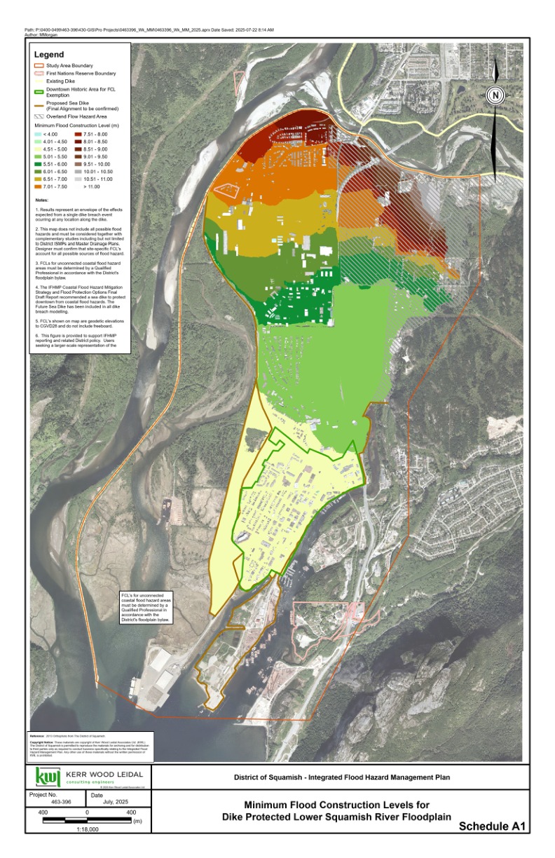
Current floodplain bylaw & maps
Find your area on the map, then confirm the required flood level and elevation reference with the District and your professional.
Read the District documentDistrict of Squamish / Kerr Wood Leidal · Schedule A1
Bylaw 3184 adopted September 2025; map July 2025 · Updated October 3, 2026
Flood Construction Level (FCL) sets the required elevation for your property. It is not a standard height above every backyard.
Which flood document should I use?
Use Floodplain Management Bylaw 3184 and its maps. The 2018 guide provides background. Have your professional confirm the property’s required elevation and reference level.
Flood rules can affect floors, equipment, foundations and materials below FCL. Floodways and debris-flow areas may also restrict development, even with a raised building.
Flood & debris flow
Check the mapped policy area and whether a qualified professional's risk assessment or covenant is required.
Wildfire & environment
Check relevant development permit areas, watercourses, habitat and tree requirements before clearing or designing.
The residential checklist directs applicants to address applicable land development permits before building permit submission. Its posted version is dated February 2022, so confirm the current submission requirements with the District.
Is there a stream, wetland or ditch nearby?
Check streamside protection before fixing the building location or clearing vegetation. A watercourse can affect the space available for the house, driveway and service trenches.
Assessment area
The District describes a 30 m riparian assessment area around streams, ravines, wetlands, lakes and ditches. This identifies land that needs an environmental check. Marine shorelines have additional provisions.
Protected setback
A Qualified Environmental Professional (QEP) establishes the Streamside Protection and Enhancement Area (SPEA). This protected setback differs from the assessment area. Confirm its boundaries before placing the building.
Does a seasonal stream or ditch count?
Yes, it can. Seasonal watercourses and some connected ditches, springs and wetlands qualify. The District also classifies ditches by habitat value. Ask the District and your QEP about the feature beside your lot.
What should I check on the District map?
Look for streams, wetlands, ditches and DPA 1 Environmental Review Areas. Maps can miss features or place them inaccurately, so the conditions on the ground still need checking. Give your designer the survey, environmental findings and any title restrictions together.
Open the District property mapWhat can this add to the project?
- Environmental assessment and development permit work.
- Changes to access, excavation, vegetation or the layout.
- Protection measures and construction site checks.
Work in or around water may also need provincial or federal review. Have your QEP define the scope before pricing.
Confirm the permit or exemption with the District. The review can apply to soil, vegetation, buildings and services, not only to a new house. Get the environmental requirements settled before committing to site work.
Checked October 3, 2026. BC has announced RAPR amendments taking effect January 1, 2027. If your application or work extends into 2027, ask your QEP and the District which requirements and transition provisions apply.
District streamside guidance · BC riparian requirements · Who to involve and when
Can we get services and equipment to the building?
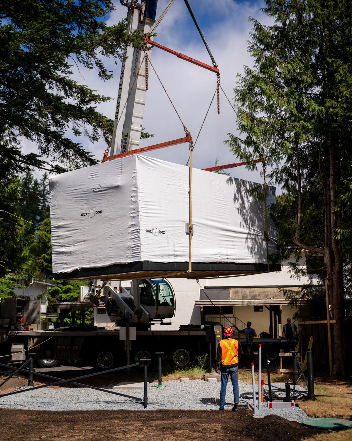 Crane reach + staging spaceSpace for delivery
Have your servicing team confirm the water, sewer, stormwater and power routes, levels and capacity. An existing sewer line does not guarantee gravity drainage will work.
Check access for people, fire response, equipment and deliveries. Trees, wires, turning space and material storage can all affect the plan.
What can change the budget here?
Longer trenches, service upgrades, a pumping system, drainage work, retaining structures, protected trees and difficult equipment access can all add scope. Ask for these to be identified individually rather than hidden in a general site-work allowance.
Check before clearing trees or moving soil
Trees
The District adopted its updated Tree Management Bylaw in May 2026. Check regulated trees, environmentally sensitive areas, replacement requirements and protection of retained trees before setting the footprint.
Use the District tree toolsExcavation & fill
Soil movement of 30 m³ or more on one parcel over 12 months falls under the District’s soil rules. Smaller amounts can also need permission around sensitive areas, steep slopes, floodways or invasive species.
Check the soil permit requirementsWhat to check before paying for drawings
Before detailed design, ask your team which options are workable, which reports are needed and what remains unknown.
See who to involve and whenCHECK THE SOURCE
Sources for this guide
Squamish Zoning Bylaw 2200 · September 2026 consolidationDistrict · Floodplain Management Bylaw 3184, adopted September 2025District · Property map and layersDistrict · Riparian and aquatic protectionDistrict · Environmental bylaws, DPA 1 and mappingProvince · Riparian Areas Protection Regulation and upcoming changesBC Laws · Current Riparian Areas Protection RegulationDistrict · Tree management (2026 bylaw)District · Soil movement permitsDistrict · Servicing agreementsDistrict · Flood management guideDistrict · Residential permit checklist (dated February 2022; still linked)District · Application guides, forms and resourcesDistrict · R-1 zoning excerpt (includes 2024 amendments)Last updated October 3, 2026. Requirements can change and depend on your property. Use these sources with your designer and the District to confirm the surveys, advice and approvals needed. Concept drawings simplify construction details.